Machu Picchu
| Historic Sanctuary of Machu Picchu* | |
|---|---|
| UNESCO World Heritage Site | |
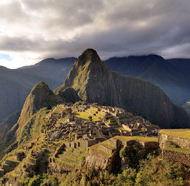
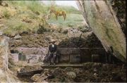
Huayna Picchu towers above the ruins of Machu Picchu |
|
| State Party | |
| Type | Mixed |
| Criteria | i, iii, vii, ix |
| Reference | 274 |
| Region** | Latin America and The Caribbean |
| Inscription history | |
| Inscription | 1983 (Seventh Session) |
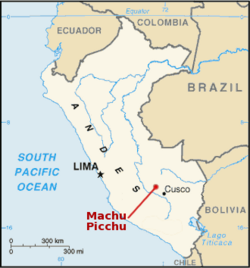
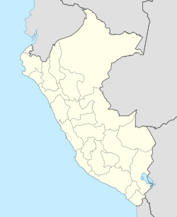 Map showing location of Machu Picchu in Peru
|
|
| * Name as inscribed on World Heritage List. ** Region as classified by UNESCO. |
|
Machu Picchu (Quechua: Machu Pikchu) – "Old Mountain", pronounced [ˈmɑtʃu ˈpixtʃu]) is a pre-Columbian Inca site located 2,430 metres (7,970 ft) above sea level.[1][2] It is situated on a mountain ridge above the Urubamba Valley in Peru, which is 80 kilometres (50 mi) northwest of Cuzco and through which the Urubamba River flows. Most archaeologists believe that Machu Picchu was built as an estate for the Inca emperor Pachacuti (1438–1472). Often referred to as "The Lost City of the Incas", it is perhaps the most familiar icon of the Inca World.
The Incas started building the estate around AD 1400 but it was abandoned as an official site for the Inca rulers a century later at the time of the Spanish conquest of the Inca Empire. Although known locally, it was unknown to the outside world before being brought to international attention in 1911 by the American historian Hiram Bingham. Since then, Machu Picchu has become an important tourist attraction and, since it was not found and plundered by the Spanish after they conquered the Incas, it is important as a cultural site.
Machu Picchu was declared a Peruvian Historical Sanctuary in 1981 and a UNESCO World Heritage Site in 1983.[2] In 2007, Machu Picchu was voted one of the New Seven Wonders of the World in a worldwide Internet poll.
Machu Picchu was built in the classical Inca style, with polished dry-stone walls. Its primary buildings are the Intihuatana, the Temple of the Sun, and the Room of the Three Windows. These are located in what is known by archaeologists as the Sacred District of Machu Picchu. In September 2007, Peru and Yale University reached an agreement regarding the return of artifacts which Hiram Bingham had removed from Machu Picchu in the early twentieth century.
Contents |
History
Machu Picchu was built around 1450, at the height of the Inca Empire.[3] It was abandoned just over 100 years later, in 1572, as a belated result of the Spanish Conquest.[3][4] It is likely that most of its inhabitants were wiped out by smallpox before the Spanish conquistadores arrived in the area, and it appears that they were aware of a place called Piccho although there is no record of the Spanish having visited the remote city. The Conquistadors defaced sacred rocks in other locations but they are untouched at Machu Picchu.[4]
One of the earliest theories about the purpose of the citadel, by Hiram Bingham, is that it was the traditional birthplace of the Incan "Virgins of the Suns".[5] Research conducted by scholars, such as John Rowe and Richard Burger, has convinced most archaeologists that Machu Picchu was an estate of the Inca emperor, Pachacuti.[4] In addition, Johan Reinhard presented evidence that the site was selected because of its position relative to sacred landscape features such as its mountains, which are purported to be in alignment with key astronomical events that would have been important to the Incas.
Another theory maintains that Machu Picchu was an Inca "llaqta", a settlement built to control the economy of these conquered regions. Yet another asserts that it may have been built as a prison for a select few who had committed heinous crimes against Inca society. An alternative theory is that it is an agricultural testing station, the purpose of which is to test different types of crops in the many different micro-climates afforded by the location and the terraces, which were not enough to grow food on a large scale, as much to determine what could grow where. But one theory suggests that the city was built for the gods to live in or for kings to be crowned there as an event.[6]
Although the citadel is located only about 80 kilometers (50 miles) from Cusco, the Inca capital, it was never found by the Spanish and consequently not plundered and destroyed, as was the case with many other Inca sites.[4] Over the centuries, the surrounding jungle grew over much of the site, and few knew of its existence.
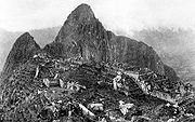
On 24 July 1911, Machu Picchu was brought to the attention of scholars by Hiram Bingham, an American historian employed as a lecturer at Yale University. Bingham had been searching for the city of Vilcabamba, the last Inca refuge and spot of resistance during the Spanish conquest of Peru. He had spent years in previous trips and explorations around the zone. Bingham was led up to Machu Picchu by a local 11 year-old Quechuas boy named Pablito Alvarez.[7][4] Some Quechuas people were living in Machu Picchu, in the original Inca infrastructure.
Bingham undertook archaeological studies and completed a survey of the area. He coined the name "The Lost City of the Incas", which was the title of his first book. Bingham made several more trips and conducted excavations on the site through 1915, collecting various artifacts. He wrote a number of books and articles about the discovery of Machu Picchu in his lifetime.
The site received significant publicity after the National Geographic Society devoted their entire April 1913 issue to Machu Picchu.
An area of 325.92 square kilometers surrounding Machu Picchu was declared a "Historical Sanctuary" of Peru in 1981. In addition to the ruins, this sanctuary area includes a large portion of adjoining region, rich with flora and fauna.
Machu Picchu was designated as a World Heritage Site in 1983 when it was described as "an absolute masterpiece of architecture and a unique testimony to the Inca civilization".[1]
The World Monuments Fund placed Machu Picchu on its 2008 Watch List of the 100 Most Endangered Sites in the world because of environmental degradation resulting from the impact of tourism, uncontrolled development in the nearby town of Aguas Calientes that included a poorly sited tram to ease visitor access, and the construction of a bridge across the Vilcanota River that is likely to bring even more tourists to the site in defiance of a court order and government protests against it.
Early encounters
Although Bingham was the first person to bring word of the ruins to the outside world, other outsiders allegedly came across Machu Picchu before him.
Simone Waisbard, a long-time researcher of Cusco, claims that Enrique Palma, Gabino Sánchez, and Agustín Lizárraga left their names engraved on one of the rocks at Machu Picchu on 14 July 1901. In 1904, an engineer named Franklin supposedly spotted the ruins from a distant mountain. He told Thomas Payne, an English Christian missionary living in the region, about the site, Payne's family members claim. They also report that in 1906, Payne and another fellow missionary named Stuart E McNairn (1867–1956) climbed up to the ruins.
The site may have been discovered and plundered in 1867 by a German businessman, Augusto Berns.[8] There is some evidence that a German engineer, J. M. von Hassel, arrived earlier. Maps found by historians show references to Machu Picchu as early as 1874.[9]
Geography
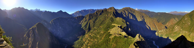
Machu Picchu lies in the southern hemisphere, some 13 degrees south of the equator.[10] It is 80 kilometers northwest of Cusco, on the crest of the mountain Machu Picchu, located about 2,450 metres (8,040 ft) above mean sea level, over 1,000 metres (3,300 ft) lower than Cusco, which has an altitude of 3,600 metres (11,800 ft).[10] As such, it had a milder climate than the Inca capital. It is one of the most important archaeological sites in South America, one of the most visited tourist attractions in all of Latin America[11] and is the most visited tourist attraction in Peru.
The year at Machu Picchu is divided between wet and dry seasons, with the majority of annual rain falling from October through to April although it can rain at any time of the year.[10]
Machu Picchu is situated above a loop of the Urubamba River, which surrounds the site on three sides, with cliffs dropping vertically for 450 metres (1,480 ft) to the river at their base. The area is subject to morning mists rising from the river.[4] The location of the city was a military secret, and its deep precipices and mountains provide excellent natural defenses. The Inca Bridge, an Inca rope bridge, across the Urubamba River in the Pongo de Mainique, provided a secret entrance for the Inca army. Another Inca bridge to the west of Machu Picchu, the tree-trunk bridge, at a location where a gap occurs in the cliff that measures 6 metres (20 ft), could be bridged by two tree trunks. If the trees were removed, it would leave a 570 metres (1,870 ft) fall to the base of the cliffs, also discouraging invaders.
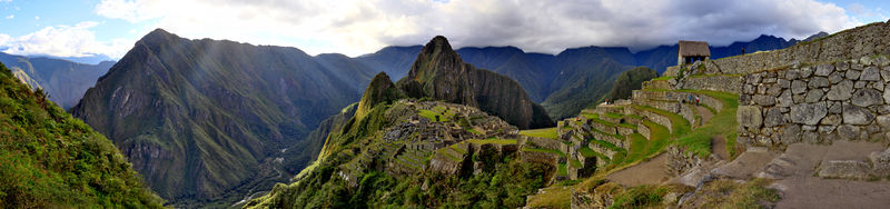
The city sits in a saddle between the two mountains Machu Picchu and Huayna Picchu,[4] with a commanding view down two valleys and a nearly impassable mountain at its back. It has a water supply from springs that cannot be blocked easily, and enough land to grow food for about four times as many people as ever lived there. The hillsides leading to it have been terraced, not only to provide more farmland to grow crops, but to steepen the slopes which invaders would have to ascend. The terraces also helped reduce soil erosion and protected against landslides.[12] There are two high-altitude routes from Machu Picchu across the mountains back to Cusco, one through the sun gate, and the other across the Inca bridge. Both could be easily blocked, should invaders approach along them. Regardless of its original purpose, it is strategically located and readily defended.
The site
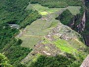
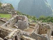
The ruins of Machu Picchu are divided into two main sections known as the Urban and Agricultural Sectors, divided by a wall. The Agricultural Sector is further subdivided into Upper and Lower sectors, while the Urban Sector is split into East and West sectors, separated by wide plazas.[4]
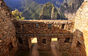
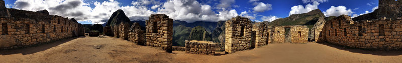
The central buildings of Machu Picchu use the classical Inca architectural style of polished dry-stone walls of regular shape. The Incas were masters of this technique, called ashlar, in which blocks of stone are cut to fit together tightly without mortar. The Incas were among the best stone masons the world has seen, and many junctions in the central city are so perfect that it is said not even a blade of grass fits between the stones.
.jpg)
.jpg)
Some Inca buildings were constructed using mortar, but by Inca standards this was quick, shoddy construction, and was not used in the building of important structures. Peru is a highly seismic land, and mortar-free construction was more earthquake-resistant than using mortar. The stones of the dry-stone walls built by the Incas can move slightly and resettle without the walls collapsing.
Inca walls show numerous design details that also help protect them from collapsing in an earthquake. Doors and windows are trapezoidal and tilt inward from bottom to top; corners usually are rounded; inside corners often incline slightly into the rooms; and "L"-shaped blocks often were used to tie outside corners of the structure together. These walls do not rise straight from bottom to top but are offset slightly from row to row.
The Incas never used the wheel in any practical manner. Its use in toys demonstrates that the principle was well-known to them, although it was not applied in their engineering. The lack of strong draft animals as well as terrain and dense vegetation issues may have rendered it impractical. How they moved and placed enormous blocks of stones remains a mystery, although the general belief is that they used hundreds of men to push the stones up inclined planes. A few of the stones still have knobs on them that could have been used to lever them into position; it is believed that after the stones were placed, the Incas would have sanded the knobs away, but a few were overlooked.
The space is composed of 140 structures or features, including temples, sanctuaries, parks, and residences that include houses with thatched roofs. There are more than one hundred flights of stone steps –often completely carved from a single block of granite –and a great number of water fountains that are interconnected by channels and water-drains perforated in the rock that were designed for the original irrigation system. Evidence has been found to suggest that the irrigation system was used to carry water from a holy spring to each of the houses in turn.
According to archaeologists, the urban sector of Machu Picchu was divided into three great districts: the Sacred District, the Popular District to the south, and the District of the Priests and the Nobility.
Located in the first zone are the primary archaeological treasures: the Intihuatana, the Temple of the Sun and the Room of the Three Windows. These were dedicated to Inti, their sun god and greatest deity. The Popular District, or Residential District, is the place where the lower class people lived. It includes storage buildings and simple houses. In the royalty area – a sector that existed for the nobility – is a group of houses located in rows over a slope; the residence of the Amautas (wise persons) was characterized by its reddish walls, and the zone of the Ñustas (princesses) had trapezoid-shaped rooms. The Monumental Mausoleum is a carved statue with a vaulted interior and carved drawings. It was used for rites or sacrifices.
As part of their road system, the Incas built a road to the Machu Picchu region. Today, tens of thousands of tourists walk the Inca Trail to visit Machu Picchu each year, acclimatising at Cusco before starting on a two- to four-day journey on foot from the Urubamba valley, up through the Andes mountain range to the isolated city. Further evidence of Machu Picchu's role in long-distance trade comes from non-local artifacts found at the site. An example of long-distance transport is the presence of unmodified obsidian nodules that were found at the entrance gateway to Machu Picchu by Bingham. In the 1970s, Burger and Asaro determined that these obsidian samples were from the Titicaca or Chivay obsidian source, and that these samples from Machu Picchu represent the further transport of this obsidian type in prehispanic Peru.[13]
The Guardhouse is a three-sided building with one of its long sides opening onto the Terrace of the Ceremonial Rock. This three-sided style of Inca architecture is known as the wayrona style.[14]
3D Laser Scanning of Site
In 2005 and 2009 the University of Arkansas carried out detailed laser scans of the entire Machu Picchu site and of the ruins at the top of the adjacent Huayna Picchu mountain. The university has made the scan data available for research purposes.[15]
January 2010 evacuation
In January 2010, heavy rain caused flooding which buried or washed away roads and railways leading to Machu Picchu, trapping over 2,000 tourists in addition to 2,000 locals. Machu Picchu was temporarily closed,[16] but it reopened on 28 February 2010.[17] Machu Picchu reopened to tourists on 1 April 2010.
Intihuatana stone
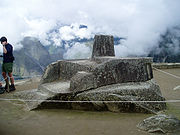
The Intihuatana stone is one of many ritual stones in South America. The Spanish did not find Machu Picchu, so the Intihuatana Stone was not destroyed, unlike many other ritual stones in Peru. These stones are arranged to point directly at the sun during the winter solstice. The name of the stone (coined perhaps by Hiram Bingham III) is Quechua: inti means 'sun', and wata- is the verb root 'to tie, hitch (up)' ('huata-' is simply a Spanish spelling). The Quechua -na suffix derives nouns for tools or places. Hence inti watana is literally an instrument or place to 'tie up the sun', often expressed in English as "The Hitching Post of the Sun" because the stone was believed to hold the sun in its place along its annual path in the sky. At midday on 21 March and 21 September the equinoxes, the sun stands almost above the pillar—casting no shadow at all.[18] Researchers believe that it was built as an astronomic clock or calendar.
The Intihuatana stone was damaged in September 2000 when a 450 kg (1,000-pound) crane fell onto it, breaking off a piece of stone the size of a ballpoint pen. The crane was being used by a crew hired by J. Walter Thompson advertising agency to film an advertisement for a beer brand. "Machu Picchu is the heart of our archaeological heritage and the Intihuatana is the heart of Machu Picchu. They've struck at our most sacred inheritance," said Federico Kaufmann Doig, a Peruvian archaeologist.[19]
Concerns over tourism
Machu Picchu is a UNESCO World Heritage Site. For this reason, a growing number of people visit Machu Picchu, reaching 400,000 in 2003.[20] As Peru's most visited tourist attraction and major revenue generator, it is continually threatened by economic and commercial forces. In the late 1990s, the Peruvian government granted concessions to allow the construction of a cable car and development of a luxury hotel, including a tourist complex with boutiques and restaurants. These plans were met with protests from scientists, academics, and the Peruvian public—all worried that the greater numbers of visitors would pose tremendous physical burdens on the ruins.[21] There were protests against a plan to build a bridge to the site as well.[22] A no-fly zone exists above the area.[23] UNESCO is considering putting Machu Picchu on its List of World Heritage Sites in Danger.[22]
During the 1980s a large rock from Machu Picchu's central plaza was moved out of its alignment to a different location in order to create a helicopter landing zone. Helicopter landings were forbidden in the 1990s. In 2006 a Cusco-based company, Helicusco, sought to have tourist flights over Machu Picchu and initially received a license to do so, but the decision was quickly overturned.[24]
Controversy with Yale University
In 1912 and 1914–15, Bingham excavated the treasures from Machu Picchu—ceramic vessels, silver statues, jewelry and human bones—and took them from Peru to Yale University in the United States for further study for a period of 18 months. Yale has retained the artifacts until now under the argument that Peru didn't have the infrastructure or proper conditions to take care of the pieces.
Eliane Karp, an anthropologist who is the wife of the former Peruvian President Alejandro Toledo, accused Yale of profiting from Peru's cultural heritage by claiming title to thousands of pieces removed from Machu Picchu by Bingham in 1912, some of which have been on display at Yale's Peabody Museum ever since. Some of the artifacts Bingham removed were returned to Peru, but Yale kept the rest saying its position was supported by federal case law involving Peruvian antiquities.[25]
On 19 September 2007, the Courant reported that Peru and Yale had reached an agreement regarding the requested return of the artifacts. The agreement includes sponsorship of a joint traveling exhibition and construction of a new museum and research center in Cusco about which Yale will advise Peruvian officials. Yale acknowledges Peru's title to all the excavated objects from Machu Picchu, but Yale will share rights with Peru in the research collection, part of which will remain at Yale as an object of continuing study.[26]
On 19 June 2008, National Geographic Society’s vice-president Terry Garcia was quoted by daily La República. “We were part of this agreement. National Geographic was there, we know what was said, the objects were lent and should be returned.”
In media
Secret of the Incas was filmed by Paramount Pictures on location at Cusco and Machu Picchu, the first time that a major Hollywood studio filmed on site. Five hundred natives were used as extras in the film.[27] The film also featured the Peruvian singer Yma Sumac as Kori-Tica. The film caused a surge in tourism to Peru in 1954.
Machu Picchu is also featured prominently in the 2004 film The Motorcycle Diaries, a biopic based on the 1952 youthful travel memoir of Marxist revolutionary Che Guevara.[28] In a review of the film, The Daily Telegraph remarked that "the scenes at Machu Picchu are worth watching several times over."[29]
See also
- Choquequirao
- Inca Trail to Machu Picchu
- Iperu, tourist information and assistance
- Kuelap
- List of archaeoastronomical sites by country
- List of largest monoliths in the world
- Putucusi, neighboring mountain
- Tourism in Peru
References
- ↑ 1.0 1.1 "UNESCO advisory body evaluation" (PDF). http://whc.unesco.org/archive/advisory_body_evaluation/274.pdf.
- ↑ 2.0 2.1 UNESCO World Heritage Centre.
- ↑ 3.0 3.1 Wright et al 2000b, p.1.
- ↑ 4.0 4.1 4.2 4.3 4.4 4.5 4.6 4.7 Wright & Valencia Zegarra 2001, 2004, p.1.
- ↑ Bingham 1922, p.334.
- ↑ Weatherford 1988, pp.60–62.
- ↑ "Machu Picchu History". http://www.ourworldwonders.com/MachuPicchu/History.htm.
- ↑ Dan Collyns (6 June 2008). "Machu Picchu ruin 'found earlier'". BBC News. http://news.bbc.co.uk/1/hi/world/americas/7439397.stm.;Michael Marshall (7 June 2008). "'Incan lost city looted by German businessman'". NewScientist. http://www.newscientist.com/channel/being-human/dn14050-incan-lost-city-looted-by-german-businessman.html?feedId=online-news_rss20.
- ↑ NYtimes.com
- ↑ 10.0 10.1 10.2 Wright & Valencia Zegarra 2001, 2004, p.ix.
- ↑ Davies 1997, p.163.
- ↑ Wright et al 2000b, p.2.
- ↑ Burger and Salazar 2004
- ↑ Wright & Valencia Zegarra 2001, 2004, p.8.
- ↑ "Computer Modeling of Heritage Resources". http://cast.uark.edu/home/education/field-programs/geomatics-for-archaeology-field-school.html.
- ↑ BBC, jhayzee27 (29 January 2010). "Machu Picchu Airlift Rescues 1,400 Tourists". Disaster Alert Network LLC. UBAlert. http://www.ubalert.com/a/14452. Retrieved 7 February 2010.
- ↑ travel staff, Seattle Times (5 February 2010). "Machu Picchu to reopen earlier than expected after storms". The Seattle Times. http://seattletimes.nwsource.com/html/travel/2010992388_webperu05.html?syndication=rss. Retrieved 7 February 2010.
- ↑ "Machu Picchu, Peru". http://64.233.183.104/search?q=cache:JSwdbm9AmYwJ:www.sacredsites.com/americas/peru/machu_picchu.html+%22Intihuatana+Stone%22&hl=en&ct=clnk&cd=1&client=firefox-a.
- ↑ (– Scholar.Google.co.uk) Sacred stone in Machu Picchu damaged during beer commercial. CNN. 12 September 2000. http://archives.cnn.com/2000/WORLD/americas/09/11/peru.machupicchu.ap/
- ↑ "Row erupts over Peru's tourist treasure", BBC News Online. 27 December 2003
- ↑ Sacredland.org, Sacred Land Film Project.
- ↑ 22.0 22.1 "Bridge stirs the waters in Machu Picchu", BBC News Online, 1 February 1, 2007
- ↑ "Peru bans flights over Inca ruins", BBC News Online, 8 September 2006
- ↑ Collyns, Dan (2006-09-08). "Peru bans flights over Inca ruins". BBC News. http://news.bbc.co.uk/2/hi/americas/5326042.stm. Retrieved 2010-08-24.
- ↑ "Hartford Courant. "Peru Presses Yale On Relics." 14 March 2006.". http://peacecorpsonline.org/messages/messages/467/2045289.html.
- ↑ Hartford Courant. "Yale To Return Incan Artifacts" by Edmund H. Mahoney. 19 September 2007
- ↑ Production Notes – Secret Of The Incas @ TCM Database
- ↑ Excerpted Clip of Machu Picchu from the film The Motorcycle Diaries directed by Walter Salles, distributed by Focus Features, 2004
- ↑ Wheels On Film: The Motorcycle Diaries by Nick Cowen and Hari Patience, The Daily Telegraph, April 27, 2009
Bibliography
-
- Bingham, Hiram (1922). Inca Land: explorations in the highlands of Peru. Boston, Massachusetts, USA: Houghton Mifflin. OCLC 248230298.
- Bingham, Hiram (1930, 1979). Machu Picchu, a citadel of the Incas. New York, USA: Hacker Art Books. ISBN 9780878172528. OCLC 6579761.
- Burger, Richard; and Lucy Salazar (eds.) (2004). Machu Picchu: Unveiling the Mystery of the Incas. New Haven, Connecticut, USA: Yale University Press. ISBN 9780300097634. OCLC 52806202.
- Davies, Nigel (1997). The Ancient Kingdoms of Peru. London, UK and New York, USA: Penguin Books. ISBN 0-14-023381-4. OCLC 37552622.
- Frost, Peter; Daniel Blanco; Abel Rodríguez and Barry Walker (1995). Machu Picchu Historical Sanctuary. Lima, Peru: Nueves Imágines. OCLC 253680819.
- MacQuarrie, Kim (2007). The Last Days of the Incas. New York, USA: Simon & Schuster. ISBN 978-0743260497. OCLC 77767591.
- Magli, Giulio (2009). "At the other end of the sun’s path: A new interpretation of Machu Picchu" (PDF). http://arxiv.org/ftp/arxiv/papers/0904/0904.4882.pdf. Retrieved 12 Jan. 2010.
- Reinhard, Johan (2007). Machu Picchu: Exploring an Ancient Sacred Center. Los Angeles, California, USA: Cotsen Institute of Archaeology, UCLA. ISBN 9781931745444. OCLC 141852845.
- Richardson, Don (1981). Eternity in their Hearts. Ventura, California, USA: Regal Books. pp. 34–35. ISBN 0-8307-0925-8. OCLC 491826338.
- UNESCO World Heritage Centre. "Historic Sanctuary of Machu Picchu". UNESCO World Heritage Centre. http://whc.unesco.org/pg.cfm?cid=31&id_site=274. Retrieved 10 Jan. 2010.
- Weatherford, J. McIver (1988). Indian givers: how the Indians of the Americas transformed the world. New York, USA: Fawcett Columbine. ISBN 0-449-90496-2. OCLC 474116190.
- Wright, Kenneth; Alfredo Valencia Zegarra (2000). Machu Picchu: A Civil Engineering Marvel. Reston, Virginia, USA: ASCE Press (American Society of Civil Engineers). ISBN 9780784404447. OCLC 43526790.
- Wright, Kenneth R.; Alfredo Valencia Zegarra and Christopher M. Crowley (May 2000a). "Completion Report to Instituto Nacional de Cultura on Archaeological Exploration of the Inca Trail on the East Flank of Machu Picchu and on Palynology of Terraces Part 1" (PDF). http://www.wrightpaleo.com/pdf/MP%20East%20Flank%20Report%20Pt%201%20Cover.pdf. Retrieved 14 Jan. 2010.
- Wright, Kenneth R.; Alfredo Valencia Zegarra and Christopher M. Crowley (May 2000b). "Completion Report to Instituto Nacional de Cultura on Archaeological Exploration of the Inca Trail on the East Flank of Machu Picchu and on Palynology of Terraces Part 2" (PDF). http://www.wrightpaleo.com/pdf/MP%20East%20Flank%20Report%20Pt%202%20Text.pdf. Retrieved 14 Jan. 2010.
- Wright, Kenneth R.; Alfredo Valencia Zegarra and Christopher M. Crowley (May 2000c). "Completion Report to Instituto Nacional de Cultura on Archaeological Exploration of the Inca Trail on the East Flank of Machu Picchu and on Palynology of Terraces Part 3" (PDF). http://www.wrightpaleo.com/pdf/MP%20East%20Flank%20Report%20Pt%203%20Drawings.pdf. Retrieved 14 Jan. 2010.
- Wright, Ruth M.; Dr. Alfredo Valencia Zegarra (2001, 2004). The Machu Picchu Guidebook: A self-guided tour (Revised ed.). Boulder, Colorado, USA: Johnson Books. ISBN 1-55566-327-3. OCLC 53330849. http://books.google.com/?id=xef8JWgrDlsC&printsec=frontcover&dq=The+Machu+Picchu+Guidebook:+A+self-guided+tour&cd=1#v=onepage&q=.
Further reading
-
- Kops, Deborah (2009). Machu Picchu. Minneapolis, Minnesota, USA: Twenty-First Century Books. ISBN 9780822575849. OCLC 189667204. http://books.google.com/?id=57mqdKhFIF8C&printsec=frontcover&dq=%22Machu+Picchu%22&cd=6#v=onepage&q=.
External links
- UNESCO – Machu Picchu (World Heritage)
- Wright Paleohydrological Institute with reports on water management at Machu Picchu
- 3D model of Machu Picchu
- GigaPan image of Machu Picchu
- Machu Picchu travel guide from Wikitravel
- Machu Picchu at the Open Directory Project
- Mysteries of Machu Picchu - slideshow by Life magazine
|
|||||||

|
|||||||

|
|||||||||||||||||||||||||||||||||||
|
|||||